Iceland's Fimmvörðuháls & Laugavegur Trail – Six Days Across a Volcanic Wilderness
*An 80 km wild camping adventure from Skógar to Landmannalaugar*
Iceland had been on my list of places to explore for some time, and the opportunity to combine two of the country's most spectacular trekking routes into one continuous six-day adventure was something I was really looking forward to.
The plan was to complete both the Fimmvörðuháls and Laugavegur trails, travelling from Skógar on the southern coast of Iceland all the way through to Landmannalaugar in the highlands.
Unlike the more traditional direction of travel along the Laugavegur Trail, we chose to walk from south to north, meaning that we would finish our journey amongst the colourful volcanic mountains and geothermal landscapes of Landmannalaugar.
This was also a valuable opportunity for me to gain further mountain experience as part of my preparation towards my International Mountain Leader (IML) qualification.
There were just two of us on this adventure, myself and my wife, carrying our equipment and camping along the route.
Over six days, we would encounter everything from spectacular waterfalls and snow-covered mountain passes to exposed ridges, glacial river crossings, vast black volcanic deserts and some of the most incredible mountain landscapes I've experienced.
Day 1 – Skógar to Baldvinsskáli
Distance: 12 km | Ascent: 1,000 m | Time: 4–5 hours
Our adventure began at the spectacular Skógafoss waterfall, one of Iceland's most recognisable natural landmarks.
After a long journey across Iceland by bus, we arrived at the trailhead later than originally planned, but with clear skies and virtually no wind, conditions couldn't have been much better for our first day.
The route begins with a steep climb up the steps beside Skógafoss before joining a well-established trail following the Skógá River.
What followed was an incredible succession of waterfalls, each seemingly more impressive than the last. The trail gradually gained height alongside the river, offering continuous views of the surrounding landscape.
Navigation was relatively straightforward, with a well-trodden path and the river providing an obvious handrail for much of the route.
One of our main navigational features was the footbridge approximately 8 km into the walk. Reaching this marked the point where we would leave the river behind and begin following the gravel tracks towards our first overnight stop.
As we continued climbing, the landscape became increasingly barren and volcanic, a dramatic contrast to the lush green scenery we had experienced earlier in the day.
Eventually, we reached Baldvinsskáli, perched high on the mountain just before the glacier plateau.
We arrived at approximately 8 pm, having started late because of our travel arrangements.
It had been a fantastic introduction to Icelandic trekking, with spectacular waterfalls, straightforward navigation and almost perfect weather.
A rewarding first day, and already a taste of the incredible variety of scenery this route had to offer.
Day 2 – Baldvinsskáli to Þórsmörk
Leaving Baldvinsskáli, we headed back out onto the volcanic gravel tracks and towards the Fimmvörðuháls mountain pass.
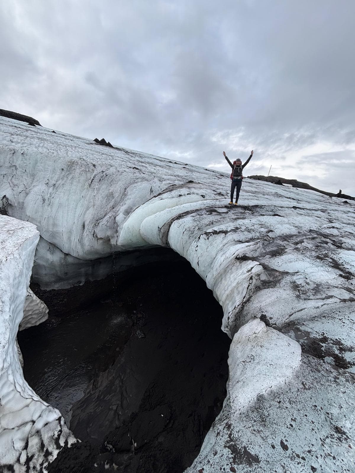
Despite the favourable weather, the higher ground was still very wintery, with snow and ice remaining across sections of the route.
After assessing the terrain, we decided to change into our microspikes for a short section where additional traction was needed.
The route initially took us across steep and occasionally technical snow-covered terrain before descending towards the volcanic lava fields.
One of the most fascinating aspects of this section was walking across lava created during the 2010 eruption of Eyjafjallajökull.
To think that the ground beneath our feet had been formed only a relatively short time ago was quite remarkable.
Following the trail markers, we made our way across the lava fields before beginning the climb towards Brattafönn and Heljarkambur.
This was where the route became particularly exciting.
A steep ascent, assisted by fixed chains, led us towards an exposed ridge with some absolutely breathtaking views across the surrounding mountains.
The terrain was certainly more adventurous here, but the views made every metre of climbing worthwhile.
Continuing onwards, we crossed Morinsheiði, where the landscape opened up to reveal magnificent panoramic views towards Mýrdalsjökull and the volcanic surroundings of Katla.
The trail then narrowed again as we approached Kattarhryggir, known as the *Cat's Spine*.
From a distance, this section looks quite intimidating, with a narrow ridge cutting through the surrounding mountain terrain. However, in the conditions we experienced, the crossing was manageable and another memorable part of the day.
The scenery throughout this section was simply outstanding.
Eventually, we began the steep descent towards Þórsmörk, and once again the landscape changed dramatically.
The black volcanic terrain gradually gave way to green hillsides, valleys and vegetation.
It was difficult to believe how much the scenery had changed in just a few hours.
Our final challenge was reaching the campsite at Langidalur.
Unfortunately, recent poor weather had resulted in the usual river bridge being moved, meaning we couldn't complete the crossing as originally planned.
Thankfully, with assistance from local transport, we were able to cross safely and reach our second overnight stop.
An incredible mountain day, combining snow, lava fields, exposed ridges and some of the finest scenery of the entire adventure.
Day 3 – Þórsmörk to Emstrur
Waking up at Langidalur was a pleasure.
The campsite sits in a beautiful valley surrounded by green mountains, and with another favourable weather forecast, we were looking forward to the next stage.
Leaving camp, we began with a steep climb through woodland.
This was another completely different landscape from the previous two days, with established vegetation and trees providing a welcome contrast to the exposed volcanic terrain.
As we gained height, we knew that one of our first challenges would be a river crossing.
We had already heard reports that water levels were quite high, so we approached the crossing knowing that we would need to assess conditions carefully.
On arrival, it was clear that the river was flowing strongly.
There were two separate sections to cross, so we spent time looking at several possible locations before deciding on the most suitable place.
The water was approximately two feet deep in places and moving quickly, but after assessing the depth, current and crossing points, we felt the conditions were manageable.
Changing into our river-crossing shoes, we crossed both sections successfully.
From there, the trail led us back into Iceland's vast volcanic landscapes.
For the next few hours, the walking was relatively straightforward, following long, open trails across the lava fields.
The scale of the landscape was impressive, with enormous open spaces and distant mountains stretching in every direction.
Later in the day, we approached another substantial river.
Initially, the depth and speed of the water were concerning, but as we followed the trail, we discovered a steep descent protected by safety chains leading towards a large footbridge.
This provided a safe crossing and avoided the need to enter the water.
After climbing away from the river, we continued following the marked trail towards Emstrur.
The campsite was another excellent location, and we were pleased to settle in for the evening.
The weather became more unsettled, with intermittent wind and rain, but the campsite had some useful shelters for those camping.
Three days completed, and already we had experienced an incredible variety of terrain.
Day 4 – Emstrur to Álftavatn
Leaving Emstrur, the initial terrain was rugged and undulating, with numerous small climbs, descents and deep canyons cutting through the landscape.
We knew this section would involve several river crossings, so we were particularly interested in how the recent poor weather might have affected water levels.
The route would also take us past Hvanngil hut, which provided a useful landmark along the way.
Much of the day's walking crossed the extraordinary volcanic landscapes associated with the Mælifellssandur desert.
These vast expanses of black sand and volcanic rock are difficult to describe until you've experienced them.
The scenery was almost otherworldly, with enormous open spaces, distant mountain ranges and very little vegetation.
Despite the remote setting, navigation was relatively straightforward thanks to the clear weather, established trails and frequent route markers.
As we approached Hvanngil, we needed to locate the trail leading towards the footbridge across the Kaldaklofskvísl River.
After crossing successfully, our attention turned to the Bláfjallakvísl River.
This river is known for becoming particularly challenging during periods of heavy rain and increased glacial meltwater.
Given the recent poor weather, it was something we had been thinking about throughout the day.
Fortunately, after assessing the conditions and identifying a suitable crossing point, we were able to cross together without difficulty.
With the major river crossings behind us, we continued towards Álftavatn.
The landscape gradually changed once again, with the beautiful lake and surrounding mountains providing a stunning setting for our fourth overnight stop.
It had been another rewarding day, and with two days remaining, we were now heading towards some of the most colourful and geologically fascinating sections of the route.
Day 5 – Álftavatn to Hrafntinnusker
Day five would turn out to be one of the most visually spectacular days of the entire trek.
Leaving Álftavatn, we initially followed relatively flat terrain, allowing us to cover the first few kilometres at a comfortable pace.
Before long, we reached the Grashagakvísl River.
Once again, water levels were relatively high, but after assessing the crossing, we were able to make our way through successfully.
Beyond the river, the terrain began to change significantly.
We approached the steep climb towards Jökultungur, which was considerably more demanding than the earlier sections of the day.
The trail was also noticeably busier, with walkers travelling in both directions.
After gaining height, we continued following the trail markers across the Kaldaklofsfjöll mountains.
What followed was some of the most incredible scenery we had encountered anywhere in Iceland.
The landscape opened up into an extraordinary collection of colourful mountain ridges, deep ravines and volcanic rock formations.
The colours were astonishing.
Yellow, orange, red and green slopes stretched into the distance, creating a landscape that seemed almost unreal.
Adding to the atmosphere were the numerous geothermal features scattered throughout the mountains.
Steam rose from vents in the ground, providing a constant reminder of the volcanic activity taking place beneath our feet.
Walking so close to these geothermal areas was one of the highlights of the entire adventure.
It was a fascinating environment, and we frequently stopped simply to take in the scenery.
The final four or five kilometres towards Hrafntinnusker involved a succession of short climbs and descents across rugged volcanic terrain.
After several days of trekking, these constant undulations certainly made themselves felt.
Eventually, we arrived at Hrafntinnusker and settled into our final overnight stop.
With almost the entire route behind us, there was a real sense of satisfaction.
We had experienced five very different days of trekking, and now only one relatively short stage remained.
Day 6 – Hrafntinnusker to Landmannalaugar
One of the reasons we had chosen to complete the route from south to north was that our final day would be shorter, giving us the opportunity to enjoy the last section without feeling rushed.
Leaving Hrafntinnusker, we followed gently undulating trails across the volcanic highlands.
Some of the terrain reminded me of the Glyderau in Eryri (Snowdonia), with rocky mountain paths, rugged ground and a succession of small climbs and descents.
The obvious difference was the volcanic rock, particularly the extensive black lava formations.
As we gradually began to descend, the landscape changed yet again.
The barren high-level terrain gave way to increasingly colourful mountains, green valleys and the extraordinary scenery surrounding the Laugahraun lava field.
The variations in colour were remarkable.
Everywhere we looked, the surrounding hillsides displayed different shades of mineral-rich volcanic rock, while geothermal steam rose from the ground in several locations.
It was an incredible environment to finish the trek.
The final kilometres took us along winding trails and down one last steep descent towards Landmannalaugar.
Black volcanic rocks and pieces of obsidian were scattered across the surrounding landscape, contrasting beautifully with the colourful mountains.
Eventually, we reached Landmannalaugar.
Six days, approximately 80 kilometres, and two of Iceland's most spectacular trekking routes completed.
It was a fantastic feeling to arrive at the finish, particularly knowing the variety of landscapes and challenges we had experienced along the way.
Reflections on Six Days in Iceland
Looking back on the adventure, what stands out most is the extraordinary diversity of Iceland's landscape.
Over the course of just six days, we had travelled alongside spectacular waterfalls, crossed snow-covered mountain terrain, negotiated exposed ridges, walked across relatively recent lava fields, descended into lush green valleys and trekked through vast black volcanic deserts.
We had also encountered numerous glacial rivers, some of which required careful consideration before attempting a crossing.
The river crossings were particularly valuable from a mountain leadership perspective.
Unlike many of the mountain environments I'm familiar with in the UK, Iceland's glacial rivers can change considerably depending on rainfall, temperature and meltwater.
Being able to assess conditions, identify suitable crossing locations and recognise when an alternative is required is an important part of operating safely in this environment.
The experience also reinforced the importance of being adaptable.
From the snow and ice encountered around Fimmvörðuháls to the relocated river bridge near Þórsmörk, the route presented situations where decisions needed to be made based on the conditions we found rather than simply following a predetermined plan.
As part of my ongoing preparation towards the International Mountain Leader qualification, the journey provided valuable experience in remote mountain travel, navigation, expedition planning and managing the practical demands of multi-day trekking.
But beyond the professional development, this was simply an incredible adventure to share with my wife.
The scenery was unlike anything I'd experienced before, and the opportunity to travel continuously through such a remarkable environment made the journey particularly rewarding.
For anyone who enjoys multi-day trekking, remote mountain environments and landscapes shaped by powerful natural forces, Iceland is a truly extraordinary destination.
Combining the Fimmvörðuháls and Laugavegur trails into one continuous journey is an experience I would thoroughly recommend to suitably experienced and well-prepared mountain walkers.
Six days of adventure, constantly changing scenery and memories that will stay with me for a very long time.
---
*Written by AZOW Outdoor Adventures*
*AZOW Outdoor Adventures provides professionally led mountain adventures, guided trekking experiences and outdoor skills courses across the UK and internationally.*